What is Loran-C?
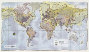
LOng RAnge Navigation, or LORAN, is a hyperbolic navigation system first developed during WWII. Its history includes the British system “Gee”, and the United States variants known as LORAN-A, LORAN-B, LORAN-C, and LORAN-D. As is want with many advanced ideas, like RADAR and even GPS, LORAN was not initially embraced by the military or government communities at the time. Private enterprise, in the form of the infamous Alfred Lee Loomis and his Radiation Laboratory, saw the potential and developed the first working solutions. As they later did with GPS, the US Navy and the US Air Force developed similar, but different systems, known as LORAN-B and CYCLAN, respectively in the 1950’s. The Navy renamed CYCLAN to LORAN-C, and it was first deployed in the United States in 1957. In 1958, the US Coast Guard took over the LORAN-C program, including overseeing engineering, research and development, and operations for the DOD and host-nation stations, worldwide. This was initially done at the Electronics Engineering Center (EECEN) and subsequently at the Loran Support Unit (LSU), both in Wildwood, NJ. The US DOD did develop another variant, known as LORAN-D, which was used for tactical bombing. As with many acronyms that move into the common lexicon, such as the transformation of RAdio Direction And Ranging to RADAR and then to radar, “LORAN” has become “Loran” and is typically used as such in modern writing. Loran-A, -B, and –D systems are no longer in service. However, LORAN-C, and its variant, Russian Chayka, operates in several countries. At one time, there were 78 operational Loran-C stations in the Northern Hemisphere. Many countries, including the United States, United Kingdom, Republic of South Korea, the Kingdom of Saudi Arabia, China, and Russia, continue to provide Loran service, and there are initiatives to upgrade and/or expand those services to Enhanced Loran, or eLoran. The map below shows the global Loran-C footprint prior to 2013.

