What is eLoran?
Although eLoran finished coalescing into the standardized system that it is today in the 1990s, it has its roots much further back in history. Enhanced Loran, or eLoran, was developed by the US Coast Guard, alongside government partners in the US and UK, industry, and academia. Each incremental improvement and upgrade in the 1970s, 1980s, and 1990s resulted in what we now call eLoran, even though we might not have called it that previously.
In the 1990s, it was simply the beginning of the Loran Modernization and Recapitalization Program that the Coast Guard was undertaking to ensure the system was efficient and effective should it operate beyond 2000. UrsaNav’s President and CEO, Charles Schue, was the first Program Manager for this effort, until his retirement from the Coast Guard in 2000. With a Congressional mandate to continue Loran beyond 2000, the FAA joined with the USCG to continue improving and advancing the system. The FAA had always been a supporter of Loran, and had paid for installing four new transmitting sites in the mid-continental United States to improve PNT for the National Airspace System.
eLoran is a major technology upgrade of Loran-C, but can be provided by the same sites and antenna technology used for Loran-C. For example, the U.S. portion of the North American Loran-C system served the CONUS, Alaska, Hawaii, and EEZ. Eighteen stations provided CONUS coverage. A further six stations were in Alaska. Five stations in Canada provided signals that were shared across the common border between the US and Canadian, thereby improving PNT service in both countries. At one point, the station in Attu, Alaska operated in partnership with two Russian Chayka stations known as Aleksandrovsk-Kamchatsky and Alexandrovsk-Sakhalinsky. Before their closure in 1993, there were also three operational “Hawaiian” stations.
When GPS was declared fully operational in 1994, the U.S. military eliminated its requirement for Loran-C. In recognition that Loran-C did not meet emerging PNT requirements, the U.S. Government invested over $160M from 1997 through 2010 to modernize and upgrade Loran-C to eLoran. The program was executed with coordination between the USCG and the FAA, and was designed and tested to meet Non-Precision Approach (NPA) performance in support of aviation, Harbor Entrance and Approach (HEA) in support of marine, and Stratum 1 time and frequency in support of communications and network operations. In addition, a variety of policy decisions were made at the U.S. executive level that recognized the value and importance of eLoran. Moreover, government, academic, and industry studies, nationally and internationally, have evaluated the operational and cost-benefit of eLoran and overwhelmingly reported positive findings. A relatively recent and authoritative study was the Benefit-Cost Assessment Refresh: The Use of eLORAN to Mitigate GPS Vulnerability for PNT Services, 11/5/2009 (prepared for the USCG/DH and FAA/DOT by the John A. Volpe NTSC, U.S. DOT, Cambridge, MA.
Despite the successful development, favorable technical assessments, and a long standing presidential mandate for a GPS backup, in 2010, eLoran funding, and Loran-C transmissions in the U.S. and Canada were terminated. But recently, with the increasing awareness of the security threat posed by GPS denial, there has been a renewed interest in eLoran. The Howard Coble Coast Guard and Maritime Transportation Act of 2014 (H.R. 5769) directed the USCG to cease activities related to the dismantling or disposal of infrastructure that supported the former Loran-C sites, and further encourages “cooperative agreements, contracts, and other agreements with Federal entities and other public or private entities, including academic entities, to develop a positioning, timing, and navigation system, including an Enhanced Loran system, to provide redundant capability in the event GPS signals are disrupted.”
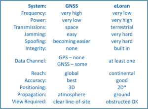
eLoran is an overlay on the internationally standardized Loran-C PNT service, and is “defined” as a PNT solution that includes transmissions synchronized to UTC, at least one Loran Data Channel (LDC), Additional Secondary Factor (ASF) mapping, and differential corrections. It is ideally suited to serve as a complement to GPS as its signal generation and transmission is quite different and completely independent of GPS as the table below indicates.

Basic eLoran PNT performance starts off good, and improves with static and dynamic configuration data. During the implementation of a fully realized eLoran service, users can take advantage of interim capabilities. The cited eLoran accuracies below are in terms of 2DRMS, 95%.
- “Basic Initial Operational Capability (IOC)”. Includes UTC synchronization, LDC, and rudimentary propagation delay corrections (ASF) based upon ITU conductivity maps and sophisticated ASF models.
-
- Timing typically better than +/- 500 nanoseconds
- Timing often better than +/- 100 nanoseconds after one-time calibration
- Positioning typically less than 100 meters
-
- “Advanced Operational Capability (AOC)”. Basic IOC eLoran plus modeled or surveyed ASF delay corrections.
-
- Timing typically better than +/- 100 nanoseconds
- Positioning typically 50-100 meters, or less
-
- “Full Operational Capability (FOC)”. AOC with differential delay corrections.
-
-
- Timing typically better than +/- 50 nanoseconds
- Positioning typically better than ten meters (~ 33 feet)
-
eLoran is a mature technology, developed on the foundation of the Loran-C system that has provided positioning, navigation, timing, frequency, and data services to civilian and military users since 1958. Its development goals included low cost of ownership, very high reliability, and improved accuracy, availability, reliability, and continuity, as compared to Loran-C.
